|
Traction Company 1894 - 1930
|
||
|
Traction Company 1894 - 1930
|
||

| |
|||
|
|||
| |
|||
|
|||
 |
|||
 |
A Tour of
Waverly, Sayre & Athens
Traction
Company.
This section
will take us on a tour around
the Valley!
taking a ride on the trolley.
For some of the scenes, there is
a "then
and
now" comparision, showing the
same location "Then" (early 20th
Century)
and "Now" (early 21st Century!)
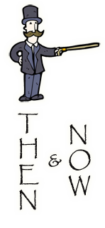
Those photos will be marked on
the side
with a Victorian Gentleman
pointing at the photo with his
cane:

When you see him, hover your mouse cursor over the photo, and the scene will change! take away the cursor, and it will change back.  .. First stop, The
headquarters for the line was the
South Waverly "car
barn".(photo above) this was where
the trollys were kept, where
repairs
and
maintance work was done, and where
the offices of the railway were
located. This building was on
Spring street, nearly across from
today's Guthrie Inn. Some of this
building still exists! and is
today
incorporated as part of the
Penelec building.
|
 |
|
  .. |
|
| |
 .. (Notice the square doors..this is probably the back of the barn.)  .. The W.S.&A.T.Co. lettering at the top of the car barn. Let's start at the car barn, and do a tour around the system. Leaving the barn, we turn right and head north on Spring street, up toward Waverly. We enter Waverly (and New York State) by passing under the Erie Railroad bridge at the corner of Broad Street and Cayuta Ave in Waverly.
|
|
| r r |
|
  |
|
| |
This is a well known intersection among Valley residents! To the right is the Erie Railroad bridge over Cayuta ave. We are standing on Broad street, looking East. The trolley on the left was heading south on Cayuta ave, and is turning west onto Broad street. The two trolleys on the right have headed North on Spring street from South Waverly, and are also turning onto Broad street. Broad street extension today heads "straight" out from the view above, however it appears it did not yet exist when the photo above was taken.  .. A close-up of Car number 3, from the photo above.  .. and a close-up of the unidentified open car, from the photo above. From this intersection, we could go in two directions, depending on which car, and which "route" we are on..we could continue North up Cayuta ave, or turn onto Broad street. Lets continue north up Cayuta ave first..We would go up to Ithaca street, where we would turn right and cross the creek, heading over the LVRR East Waverly passenger station, located where Ithaca street meets the tracks, near today's East Waverly baseball fields. Then we would turn around, and travel all the way down Ithaca street to Chemung street.  .. Corner of Ithaca street and Cayuta ave. The trolley is headed West on Ithaca street. The building above is on the site of the parking lot of the present Soprano's market.  .. We could then travel west down the middle of Chemung street, (above) or take the "belt line" up through the northern Waverly streets, via William st, Center St, Clinton ave and Pine street.  Another view of Chemung Street, looking east. Now we arrive on the west side of Waverly, at the intersection of Broad street and Elmira street. At this spot, we could change cars and transfer to the Elmira, Corning & Waverly Railway! a second streetcar line (this one called an "interurban" line since it connects several cities and towns) and take a trolley westward to Chemung, Wellsburg, Elmira and Corning!  Streetcar of the Elmira Corning & Waverly railway, at Wellsburg, NY. And! you could travel even further.. A third streetcar line interchanged with the EC&W. The "Glen Route", also known as the Elmira and Seneca Lake Railway Company, traveled from Elmira up to Watkins Glen.  Streetcar of the "Glen Route" Today one trolley car survives from these three systems. There are no (known) surviving trolley cars from the Waverly Sayre & Athens, but one car from the Elmira Corning & Waverly Railway survives! It is at the New York Museum of Transportation in Rush, NY. (South of Rochester) Which has operating trolleys from Rochester's streetcar lines! http://www.nymtmuseum.org/ At one time you could take a trolley car from the Valley, to Chemung, Wellsburg, Elmira, Corning, Horseheads, Mountour Falls, and Watkins Glen! And as I said above, there were plans in the works to also connect to the Binghamton area's streetcar line, which extended as far west as Owego..but the connection between Waverly and Owego was never made. Today we arent going to travel west of Waverly however, we are going to stick to riding only within the Valley, on our own WS&ATCo. From Elmira street, we turn onto Broad street and travel down the middle of downtown Waverly.  .. A view of Broad street in Waverly, 1895. Near the corner of Broad & Fulton streets, looking east. The old Waverly clock tower is visable. (I remember the clock tower from my childhood..it burned to the ground in 1980) Today a small replica of the clock exists in the small park at Broad & Waverly street.
|
|
|
|
  |
|
| |
Some more views of
Broad street in the Trolley Days:
 A colorized postcard made from the same photo as above.   From Waverly we can head back south to visit the rest of the Valley. We leave Broad street by travling south on Elmira street, then zig-zag our way through South Waverly streets, arriving at Keystone Avenue in Sayre in the vicinity of today's McDonalds resturant. Then we head south on Keystone Ave. Soon we pass by Keystone Park. As a trolley patron, Keystone Park might have been our destination! The park was built by the WS&ATCo as a destination, which many trolley and interurban lines did during this era. Keystone park was located at, and behind, what is today the Keystone Roller Rink and the Cider Mill, on Keystone ave just south of Pitney Street. During the parks heyday, it had a dance hall, a shooting range, picnic grounds and several amusement rides.  Keystone park opened in 1908, and was operated by the Trolley company until 1919. Then we have records that a Mr. Earl Knickerbocker of Binghamton bought and re-opened the park in 1921, and perhaps added more rides. (I suspect the roller coaster dates from this later era.) But it is currently unknown how long the park operated into the 1920's, and the exact date the park closed is still uncertain. I believe some original structures from Keystone park are still out behind the roller rink! A future goal for this webpage project is to ask for permission to take a look out there, and see if any surviving structures can be identified and photographed. If so, I will add more "then and now" photo pairs to this site. Meanwhile, some information and views of Keystone Park: An article from 1909, read down the left column first, then the right:   
The
"Keystone Central" - the
park's miniature railroad.
|
|
| |
Leaving Keystone
Park. we continue south down
Keystone
avenue:
 (does anyone recognize this specific location?) Then we turn left onto Lockhart street, pass in front of Sayre High School, and arrive in downtown Sayre, Pennsylvania.  Looking north up
Keystone ave, from the ramp of the
old walkbridge.
 A colorized postcard
from the same location. At the intersection of
Lockhart street and Desmond
street, we turn right (south) onto
Desmond Street. |
|
| |
|
  |
|
| |
 Looking at Sayre's
Desmond Street business district
from Desmond Street Park. Today this
location is *inside* the Newberrys
building! There is much interest in
restoring Desmond Street park and
returning downtown Sayre to its
original, much nicer looking
configuration. There is a the link
for a webpage about Desmond Street
park at the bottom of this page.
|
|
| |
|
|
  |
|
| |
 Restore Desmond
Street Park! :)
Imagine how nice downtown Sayre could look again.
|
|
| |
Leaving Desmond
street, we turn west onto Packer
ave,
then turn again and head South on
Elmer ave, pass in front of the
Sayre
theatre, go down two blocks then
turn West on Chemung street, and
back
to Keystone avenue. Turning south on
Keystone, we head down to Athens.
 In the postcard
above, the trolley has just
descended
the hill on North Main street, at
Walnut, and is headed south toward
downtown Athens. The houses on the
left no longer stand, and the land
they once occupied is today IR
parking lots..and all the buildings
on
the right are also gone today! and
the area to the right is today the
Dandy Minimart, and just behind the
photographer on the right, the
Agway.
Continuing south, we reach downtown Athens, PA: |
|
|
|
  |
|
|
| |
|
  |
|
|
| |
From downtown Athens, we continue south down Main street, past the Athens library, past the bridge over the Chemung river, and all the way down South Main street as far south as it goes..then there is a loop, and have we reached the southern end of the system..we turn around, and re-trace our steps back North again..here is the system map again for reference:  Now we travel back up
through Athens, and over again to
downtown Sayre..now we can take the
last remaining section that we havent
yet traveled, from downtown
Sayre, up Elmer ave to Spring street,
and back to the car barn, where
we started.. From Desmond street in
downtown Sayre, we turn onto
Lockhart street, but this time,
instead of heading back to Keystone
ave, we turn and travel north on Elmer
avenue:
From North Elmer ave,
we turn onto Mohawk for one
block, then we come to the largest
structure built by the trolley
company; The Spring Street Bridge! This bridge spanned
the LV tracks from the corner of
Spring street and North Lehigh ave, at
the intersection that today has
the "Original Italian Grille"
resturant in the old LV freight
house..The bridge went up and over
multiple tracks, then back down to
street level again between Croft
lumber and the Milltown bridge.. Looking at the site
today, you might wonder why a
bridge was needed at all.. today there
is only one track crossing
Spring street, and it only gets one or
two trains a day. But in the
late 19th century there were as many
as seven or eight tracks crossing
spring street, and some were "yard
tracks"..It was a very busy railroad
site, so the LV demanded that the
trolley company build the bridge over
the tracks, which benefited everyone.
Automobile and pedestrian traffic
also used this bridge during the 36
year run of the WS&ATCo. |
|
| |
|
  |
|
| |
Above is the intersection of Spring street and North Lehigh avenue, looking up Spring street. The Lehigh Valley freight station is to the right, which is today (in 2013) the location of the Original Italian Grille resturant.
|
|
| |
|
  North of the bridge, the buildings of the large Cayuta Wheel Foundry are visable in the background. |
|
|
|
  |
|
| |
|
  |
|
| |
This last photo (above) is from the top of the bridge, looking south into the LV Sayre yard. I was not able to get the exact same position, because the bridge no longer exists! so instead I had to use the approximate position from ground level. And now we cross
over the bridge, return to street
level between Croft Lumber and the
Milltown bridge, and head back up to
the Spring Street car barn and
offices of the Trolley company,
where
our journey began. We have done the
full loop all the way around the
Valley!
|
|
|
And that concludes
this look at the Waverly Sayre
& Athens Traction Company.
I still plan to update this page a bit! I would like to get some "then and now" comparisions of Keystone Park, and a few other areas around the system. If anyone has anything to add, please let me know! :) thanks, Scot Scot Lawrence, Rochester, NY. (Valley native, born in Sayre, grew up in Waverly! WHS class of '87) This page started in August 2013. Last updated March 3, 2016. Link to the "Restore Desmond Street Park!" webpage. Feel free to email me at: sscotsman at yahoo dot com Return to Scot's main page.
|
||
|
|


